Long Point Basin Land Trust (LPBLT) is a land conservancy that aspires to protect wildlife, ecosystems, and natural heritage across Norfolk, Elgin, and Haldimand counties.
What is a Land Conservancy (Conservation Land Trust)?
A charitable, non-governmental organization dedicated to the protection of important natural areas, wildlife, ecosystems, and cultural heritage.
Works with landowners and volunteers who wish to protect natural features, wildlife, farmland, or ecosystems
Acquires and owns land or easements held in the long-term, where conservation interests are prioritized.
Supported by volunteers, which have a wide variety of interests and skillsets
Offers an opportunity to become involved with local conservation efforts
An entity that acts to today to defend and entrench the interests of future generations in sustaining healthy ecosystems
Cooperates with other organizations to expand conservation efforts
Promotes environmental education and scientific research
Land Acknowledgement
We acknowledge that the lands we connect to and thrive on in the Long Point Basin are treaty lands and traditional territory of the Mississaugas of the Credit First Nation. The Mississaugas are an Anishinaabe (Anishin-ah-bey) people. These lands are also the traditional territory of the Neutral, Wendat and Haudenosaunee (Ho-dee-no-SHOW-nee) peoples. For thousands of years, First Nations people have been stewarding this special area of natural abundance. We recognize and deeply appreciate their knowledge and care of these lands and we are committed to respecting and welcoming the rights and responsibilities of Indigenous Peoples, working in the spirit of reconciliation.
Our History and Aspirations
Incorporated in 1996 as a charitable organization, Long Point Basin Land Trust (LPBLT) is part of the growing conservation movement in Southern Ontario. The conservancy’s first property was Jackson-Gunn Old-Growth Forest, a 9 ha parcel acquired in 2004. To date, Long Point Basin Land Trust has protected 17 properties, encompassing over 486 hectares (1201 acres). Long Point aspires to increase the rate of land protection, with more emphasis on collaborating with partner organizations, landowners, sponsors, and volunteers to make this possible. We are always willing to explore new opportunities!
Land Trust Standards and Practices
Long Point Basin Land Trust is one of the founding members of the Ontario Land Trust Alliance (OLTA), a province-wide organization representing a professional and ethical network of land conservancies in Ontario. To this end OLTA has developed a code of Standards and Practices to guide the operations of Land Trusts. LPBLT has adopted these Standards and Practices to guide the operations of the trust.
Our Landscape
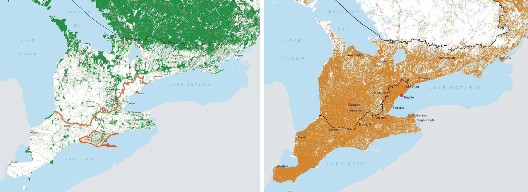
The Long Point Basin is in the centre of the Lake Erie Lowlands Ecoregion, one of Canada’s most biodiverse yet imperiled ecosystems. The area is also known as the Carolinian Life Zone due to the presence of southern flora and fauna, including trees with exotic-sounding names like Tuliptree (Liriodendron tulipifera), Sassafras (Sassafras albidum), Cucumber Magnolia(Magnolia accuminata), and Black Gum (Nyssa sylvatica). Long Point is a well-known migratory hotspot for songbirds, as well as an important wintering area for both waterfowl and raptors. It inspires botanists, having one of the most diverse floral assemblages in Canada. This region contains ~40% of Canada’s species-at-risk, and ~25% of Canada’s population, or 10 million people (though the human population is concentrated in major urban centres). The Long Point Basin also hosts a vigorous agricultural community, with Norfolk’s farmers leading Ontario’s production in many food crops – this includes asparagus, peppers, pumpkins, squash, zucchini, strawberries, cabbage, sweet corn, beans, potatoes, and many others.
Historically, habitat loss has been extensive in the Lake Erie Region. Between 1861 and 1921, the forest cover in the Lake Erie Lowlands Ecoregion dropped from 77% to 19% as they were cleared for agricultural practices. Over 70% of wetlands were also destroyed or drained. In some areas, there has been a recovery of forested areas, but much of southwestern Ontario remains a predominantly agricultural landscape.
In contrast, the Long Point Basin has experienced widespread ecological recovery in southwestern Ontario. The earliest conservation efforts included the protection of waterfowl and wetlands in the Long Point and Turkey Point marshes for hunting purposes. In the early 1900s, the St. Williams forestry station was established – Canada’s first publicly funded reforestation project, where trees were planted on sand barrens unsuitable for agriculture. Much later, Norfolk County and Long Point Region Conservation Authority (formerly the Big Creek Region Conservation Authority and Otter Creek Conservation Authority) also purchased many woodlots in the region. Following the decline of the tobacco industry, areas of former farmland near Big Creek were set aside for conservation purposes, reforested, or naturalized. This has led to Norfolk County having the highest proportion of natural cover in the Lake Erie Region, at around 25%, though Walsingham and Charlotteville are likely over 40%. This ecological recovery has resulted in a mosaic of swamps, upland forests, and tallgrass prairies, providing habitat for many of Long Point’s wildlife species! Due to the legacy of human land use, many of these habitats require stewardship to control invasive species – an ongoing and pervasive threat. Stewardship efforts in some ecosystems also mimic natural disturbance (i.e., prescribed burns, vegetation removals), historically supressed in much of Norfolk County.